![](/images/other/stat-length.png)
![Randonnée Marche La Roquebrussanne - La Roquebrussane-Jas du murier - Photo](https://media.geolcdn.com/t/1900/400/ext.pjpeg?maxdim=2&url=https%3A%2F%2Fstatic1.geolcdn.com%2Fsiteimages%2Fupload%2Ffiles%2F1553511878bg_sport_marche.png)
La Roquebrussane-Jas du murier
francisdean
Utilisateur
![Longueur](/images/other/stat-length.png)
![Altitude max](https://static1.geolcdn.com/siteimages/upload/files/1508320355ic_sort_altitude_max_24dp.png)
![Dénivelé positif](https://static1.geolcdn.com/siteimages/upload/files/1508320355ic_sort_den_pos_24dp.png)
![Km-Effort](/images/other/stat-length.png)
![Altitude min](https://static1.geolcdn.com/siteimages/upload/files/1508320355ic_sort_altitude_min_24dp.png)
![Dénivelé négatif](https://static1.geolcdn.com/siteimages/upload/files/1508320355ic_sort_den_neg_24dp.png)
![Boucle](https://static1.geolcdn.com/siteimages/upload/files/16400158638029165_repeat_loop_refresh_sync_direction_icon.png)
![Marche](https://static1.geolcdn.com/sitytour/trail-icons/101.png)
5h21
Difficulté : Moyen
![Scannez ce code QR pour ouvrir la randonnée dans l'application SityTrail](https://capi.geolives.com/qq0zvz2zws4bq2lad0pu/sitytour/trails/399269/qr.png?size=200)
Application GPS de randonnée GRATUITE
À propos
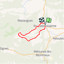
Randonnée Marche de 18,4 km à découvrir à Provence-Alpes-Côte d'Azur, Var, La Roquebrussanne. Cette randonnée est proposée par francisdean.
Description
Il n'y a pas de balisage pour cette randonnée.Suivre le tracé à l'aide du GPS. A partir du Jas du Murier, ne pas essayer de raccourcir par le Mas Fa René dont le propriétaire interdit le passage sur SES terres !! En bas, après le vallon des cerisiers et la descente raide qui arrive à la rivière, rejoignez la route en passant sur l'arrosant qui traverse l'Issole. Ne pas passer sur le pont qui mène vers un portail fermé.
Localisation
Commentaires
Randonnées à proximité
![Randonnée Marche Mazaugues - Mazaugues 21.4.24 - Photo](https://media.geolcdn.com/t/375/260/73ef7019-56c4-45d7-90ef-e1bea2022610.jpg&format=jpg&maxdim=2)
![Marche Marche](https://static1.geolcdn.com/sitytour/trail-icons/101.png)
Marche
![](/images/other/stat-length.png)
![](https://static1.geolcdn.com/siteimages/upload/files/16400158638029165_repeat_loop_refresh_sync_direction_icon.png)
![Randonnée Marche Néoules - Neoules crête 19,5 km - Photo](https://media.geolcdn.com/t/375/260/80c386c8-cc89-4ce0-b16a-56ff29c0cd34.jpg&format=jpg&maxdim=2)
![Marche Marche](https://static1.geolcdn.com/sitytour/trail-icons/101.png)
Marche
![](/images/other/stat-length.png)
![](https://static1.geolcdn.com/siteimages/upload/files/16400158638029165_repeat_loop_refresh_sync_direction_icon.png)
![Randonnée Marche La Roquebrussanne - La Roquebrussane trace réelle - Photo](https://media.geolcdn.com/t/375/260/bd781b01-e02d-463a-9f6d-1b6e26db8323.jpg&format=jpg&maxdim=2)
![Marche Marche](https://static1.geolcdn.com/sitytour/trail-icons/101.png)
Marche
![](/images/other/stat-length.png)
![](https://static1.geolcdn.com/siteimages/upload/files/16400158638029165_repeat_loop_refresh_sync_direction_icon.png)
![Randonnée Marche La Roquebrussanne - Boucle baume-fere-font-coulette - Photo](https://media.geolcdn.com/t/375/260/c19c381a-d852-4d85-81bc-d0bf63742810.jpg&format=jpg&maxdim=2)
![Marche Marche](https://static1.geolcdn.com/sitytour/trail-icons/101.png)
Marche
![](/images/other/stat-length.png)
![](https://static1.geolcdn.com/siteimages/upload/files/16400158638029165_repeat_loop_refresh_sync_direction_icon.png)
![Randonnée Marche Mazaugues - le Mourre d'Agnis au départ du Caucadis - Photo](https://media.geolcdn.com/t/375/260/dcd1794e-c5af-44e1-af91-1fadcb296c68.jpg&format=jpg&maxdim=2)
![Marche Marche](https://static1.geolcdn.com/sitytour/trail-icons/101.png)
Marche
![](/images/other/stat-length.png)
![](https://static1.geolcdn.com/siteimages/upload/files/16400158638029165_repeat_loop_refresh_sync_direction_icon.png)
![Randonnée Marche Mazaugues - Mazaugues le vallon de l'Herbette - Photo](https://media.geolcdn.com/t/375/260/62c4707c-a050-47d0-822e-64a046e156e1.jpg&format=jpg&maxdim=2)
![Marche Marche](https://static1.geolcdn.com/sitytour/trail-icons/101.png)
Marche
![](/images/other/stat-length.png)
![](https://static1.geolcdn.com/siteimages/upload/files/16400158638029165_repeat_loop_refresh_sync_direction_icon.png)
![Randonnée Marche La Roquebrussanne - la montagne de la Loube - Photo](https://media.geolcdn.com/t/375/260/ba5f3ad3-4eed-4285-a8f8-9cedf60e39f2.jpg&format=jpg&maxdim=2)
![Marche Marche](https://static1.geolcdn.com/sitytour/trail-icons/101.png)
Marche
![](/images/other/stat-length.png)
![](https://static1.geolcdn.com/siteimages/upload/files/16400158638029165_repeat_loop_refresh_sync_direction_icon.png)
![Marche Marche](https://static1.geolcdn.com/sitytour/trail-icons/101.png)
Marche
![](/images/other/stat-length.png)
![](https://static1.geolcdn.com/siteimages/upload/files/16400158638029165_repeat_loop_refresh_sync_direction_icon.png)
![Randonnée A pied Mazaugues - Mazaugues-Mourre d'Agnis-23-10-2024 - Photo](https://media.geolcdn.com/t/375/260/8bdd9a43-13c3-4a0a-a9d2-ae092f24102a.jpg&format=jpg&maxdim=2)
![A pied A pied](https://static1.geolcdn.com/sitytour/trail-icons/100.png)
A pied
![](/images/other/stat-length.png)
![](https://static1.geolcdn.com/siteimages/upload/files/16400158638029165_repeat_loop_refresh_sync_direction_icon.png)
demain